Brahmatal Trek
Overview
Duration : 6 Day
Start Point : Rishikesh
End Point : Rishikesh
Highest Altitude: 12,200 Ft.
Approx Trekking : 24 Kms.
Grade : Easy To Moderate
Description
Resting in the depths of the Uttarakhand Himalayas, the Brahmatal trek treats you to soaring views of some lofty mountain peaks such as Mt. Trishul, Mt Nanda Ghunti and Mt. Khamet. At an altitude of 3800 m, the Brahmatal trek is open throughout the winters when most of the other trekking routes are closed making it a perfect winter trek for beginners.
Brahmatal hosts one of the loveliest forest walks that are home to diverse bird species and century old oak trees. During spring, the trails of these forests are carpeted in the red and pink blooms of rhododendrons. In winters, the landscape transforms dramatically sheathing the region in pristine white snow, making it nothing short of a Winter wonderland.
Spanning over 28 km, the Brahmatal trek begins from the base village of Lohajung located in the Chamoli district in Garhwal Himalayas. The 6 km trek from Lohajung to the Gujreni campsite runs through dense forests of Conifer, Cedar, Oak and Fir. The Gujreni campsite is at the heart of a beautiful clearing surrounded by Oak and Rhododendrons with panoramic views of snow-capped ranges.
The next day, the trek gradient increases gradually. A 2-hour trek will lead you to the Bekaltal lake, frozen during the winter months, making up for a tranquil view.
Itinerary
We begin our journey to Lohajung from ISBT Dehradun latest by 7 AM. It is located at a distance of 294 km from Dehradun and would take about 11-12 hours to cover. The landscapes throughout this drive are striking.
The journey begins with a drive uphill that will take you through the Kumaon region into the Himalayan Belt of Garhwal. The roads here are extensive and the Shivalik ranges can be spotted at the horizon. The setting is tranquil and the Ganga river accompanies you swiftly throughout this stretch.
We begin from Lohajung at 9 AM. Packed lunches will be provided for the day. The trek starts on a well-paved stone trail that heads into the forest. The Nanda Ghunti Peak can be spotted right from the beginning of the trek.
After a short walk through the woods, you will come across Mandoli village tucked in to the colossal mountain ranges on your left. The trail ascends gradually in long, serpentine curves from here. Higher up, you will be able to spot the Kali Valley which is the confluence of the Kali and Pindari rivers.
The next landmark from here is a 10 m wooden bridge running over a stream where you can refill your bottles. Crossing the bridge, you will reach Begum that makes for an excellent resting point overlooking the expansive Navali and Bagdi Bugyals.
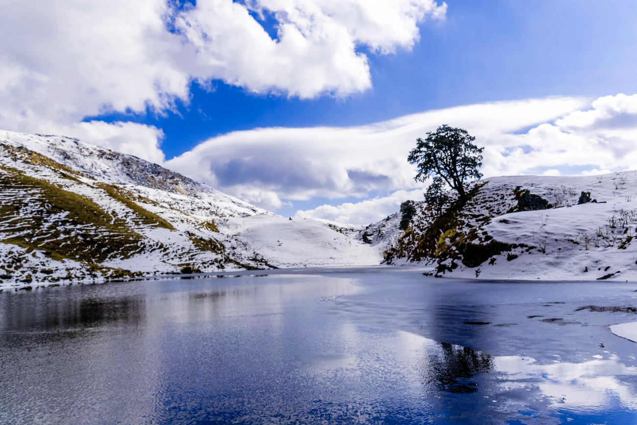
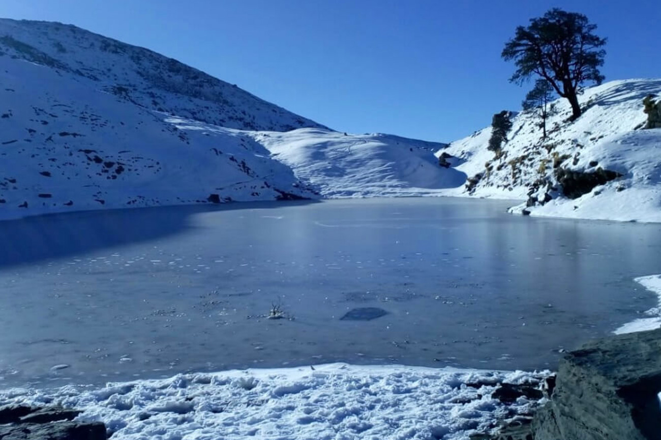
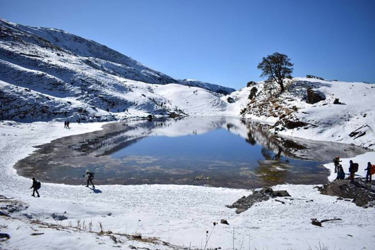
The trail from the Gujreni Campsite enters a thicket of forests with a moderate ascent throughout. You will catch the first glimpse of Mt. Trishul through the towering trees here. At a 2 hour hike away, lays the Bekaltal lake lined with Oak trees all around.
The color of the water is mud-brown indicating a high amount of dissolved organic matter. During the peak winter months, the lake is likely to be frozen. You can spend some time here immersing in the profound silence of this setting.
One can go out and explore the beautiful photography options available at this place. Be prepared for subzero temperatures that could fall even below -7 degree Celsius during peak winter nights.
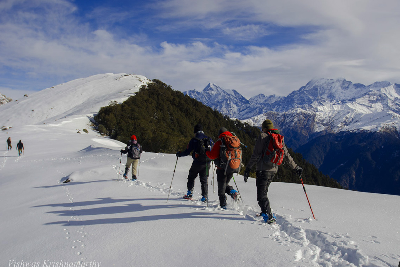
Start your day early in the morning as you will be heading towards the Brahmatal lake which is an uphill climb. You will be greeted with Oak and Rhododendron trees on the way which has a charm of their own. After a while, the zigzag ascent trail will take you Brahmatal Lake. On a bright day, the lake looks charismatic and the sunlight makes it look even more artistic. As you walk ahead you will come across a small stream which is formed by the melting of snow. You might get fooled by every passing top which will feel like the last ascent. After walking for a while and crossing the meadow, the final climb towards the pass begins.
After having your breakfast you will start your descent to Wan which is a trail filled with Oak and Rhododendron trees. This is a very beautiful trail which allows you to click end number of scenic pictures. After walking some distance you will come across a water source at Chota Tilbundi.
Half an hour later you will be able to spot Wan village which is visible below. From here onwards it will take you half an hour more to reach the road from where TTH will arrange vehicles to take you to Lohajung.
After a good night’s sleep at our Lohajung guest house, we will go back to Rishikesh today. Destination will be reached by 6:00 pm.
Highlights
- Stay at Wooden House – Meraki Triangle, Sankri
- One of the most beautiful lake and valley in Uttarakhand
- Stunning views of Swargarohini Group of Peaks & Black Peak
- High altitude expedition
- Wide variety of flora and fauna –Govind Ballabh Pant National Park
Amenities
- Food as per menu on the trek ,Accommodation. (Guest house, Home stay, Camping)
- Forest Camping charges
- Safety Equipment,Trek equipments: Sleeping bag, mattress, tent (twin sharing), kitchen & dinning tent, toilet tent, utensils and crampon (if required)
- All necessary permits and entry fees
- Trek guide, cook, helpers, and mules for carrying common luggage
- Transportation if Specified in Itinerary,
- Mountaineering qualified & professional trek Leader, guide, cook and Support staff
- Meals during road Journeyss
- Any kind of Insurance
- Any expense of personal Nature
- Any expense not specified in the inclusion list
- Carriage of personal laggage during the trek
How to reach
Take a flight to Jolly Grant Airport Dehradun, Hire a cab to reach Dehradun City as the airport is 29 km away.
The Dehradun railway station is located in the centre of the city which is well connected to all the major cities of the country.
Dehradun is easily accessible from major cities of the country as it has an excellent road connectivity with other major cities and towns of North India. There are state-run and private buses that offer a regular service.
Things To Carry
| Back pack & rain cover | (50 - 60 ltr) with comfortable shoulder straps |
| Day pack + rain cover | 20 - 30 ltr (If hire a mule or porter) |
| Walking stick | Advisable (At least one) |
| Head torch | 1 Nos. |
| Water bottle/Hydration pack | 2 bottles of one litre each People who use hydration pack- 1 hydration pack and 1 bottle of one liter Carry at least one thermos flask |
| Snacks | Energy bars, dry fruits, electral/ors |
| Personal Medical Kit | Consult your doctor |
| T-shirts | 2 Full sleeves (Non-cotton) |
| Fleece T-shirts | 1 Nos. |
| Fleece jacket | 1 Nos. (Alternative: a woollen sweater) |
| Down feather / Hollofil jacket | 1 Nos. |
| Wind & waterproof (jacket & pant) | 1 Pair |
| Thermal inners (upper and lower) | 1 Pair |
| Trek pants | 2 Synthetic (avoid shorts, fitting denims, capris) |
| Poncho | 1 Nos. |
| Sunscreen cream | Hand sanitizer |
| Moisturiser | Antibacterial powder |
| Toilet Paper & wipes | Toothbrush and toothpaste |
| Lip balm | Quick dry towel |
| Sun cap | 1 Nos. (One that covers the neck as well) |
| Woolen cap | 1 Nos. |
| Balaclava | 1 Nos. |
| Neck-gaiters | 1 Nos. |
| Sunglasses | Dark with side cover, it should be U/V protected. People who wear spectacles- (A)- Use contact lenses. (Not for Chadar trek) (B)- Photo chromatic glasses. |
| Trekking shoes | 1 Pair (Waterproof, high ankle with good grip) |
| Floaters/flip-flops | 1 Pair (Optional) |
| Cotton socks | 5 pairs |
| Woollen socks | 3 pairs |
| Gaiters | 1 Pair (Our team will notify you if required) |
| Waterproof gloves | 1 Pair |
| Fleece/woollen gloves | 1 Pair |